Concept
… of OSMoGrid and its implementation. Here, we want to focus on the overall structure of the tool and which part does serve which purpose.
The computational heaviest part is connecting households / loads to the street graph as well as clustering the loads based on the distances following the street graph. This is why we want to shift those parts to the smallest regions possible. To achieve this, a given region of interest is partitioned heuristically as much as possible. The concept is as follows:
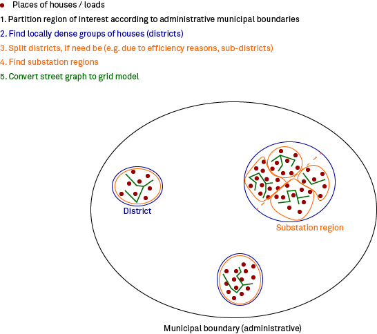
The region of interest is broken down according to the administrative boundaries until the level of municipality boundaries is reached. Moreover, these municipal boundaries are further broken down to districts. They are defined as local dense groups of houses, that do form disjoint groups. However, if those dense groups are very big, computational complexity still can be too big. So, if need be, the districts are further broken down into smaller sub-districts. Based on those (sub-)districts, cluster of loads are build, that later form the regions of secondary substations. Those clusters respect the distance between them according to the street graph, they are connected to. Lastly, the street graph is converted into a grid model.
Following this concept, the following actor hierarchy is implemented:
General
Actors related to operations that are relevant to multiple or all voltage levels:
OsmoGridGuardian
Coordination of multi voltage level spanning routine
Error handling
Collection of lv grids received from
LvCoordinatorand assigning subnet numbers
Finite state representation

InputDataProvider
Connects to OpenStreeMap (either via pbf file or API)
Acquires needed data and filters it (on request and dependent on the purpose)
ResultListener
Persisting overall grid model to sinks
Low voltage
Actors relevant to low voltage grid generation:
LvCoordinator
Coordinates the generation of the whole low voltage level
Spawns an
LvRegionCoordinatorto split up the region of interestCollects results and checks completeness
Outcome: Complete region of interest to treat
Finite state representation

LvRegionCoordinator
Splits up the region of interest according to a given administrative boundary
If the lowest administrative level has NOT been reached:
Spawns new
LvRegionCoordinators per new subregion to split up for the next lower administrative boundaryOutcome: Subregions on administrative level
n+ the next lowest administrative leveln-1
If the lowest administrative level has been reached:
Hand over the partitioned regions to a
LvGridGeneratoreachOutcome: Subregions on administrative level “municipality”
MunicipalityCoordinator
Currently not implemented!
Coordinates the region partitioning within the administrative boundary of a municipality
Determines dense and disjoint groups of houses as local “districts”
Outcome: Districts within the given municipality
DistrictCoordinator
Currently not implemented!
Breaks down districts even further, if still too big w.r.t. computational measures (to be defined)
Outcome: (Sub)districts with suitable size
SubDistrictCoordinator
Currently not implemented!
Responsible for handling a sub-district
A sub-district can also be a district, if that isn’t too big
Derives loads from houses
Connects loads to street graph
Clusters loads while respecting the distance on the street graph
Those clusters are the regions of secondary substations
Hands over the graph to
GridGeneratorsOutcome: Street subgraphs per secondary substation region
LvGridGenerator
Detects unconnected sub graphs and further clusters LV nodes into smaller sub graphs
Builds galvanically isolated lv sub grid model from sub graphs
Hands back grid model to
LvCoordinatorOutcome: Grid model per secondary substation region
Medium voltage
Actors relevant to medium voltage grid generation:
MvCoordinator
Coordinates the generation of the whole medium voltage level
Requests and handles asset type information as well as LV and HV grid data
Partitions MV nodes by using Voronoi areas defined by HV nodes once all required data has been received
Starts VoronoiCoordinator and hands over partitioned data
VoronoiCoordinator
Generates a MV graph structure
Builds a grid model based on graph structure
Returns result to MvCoordinator